About Côa Valley Grand Route
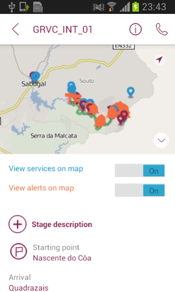
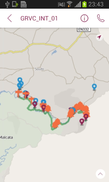
This app contains all the necessary information to support the Côa Valley Grand Route user (on foot, biking or horseback riding), including an interactive map, detailing the trail, the accesses to villages, interest...
This app contains all the necessary information to support the Côa Valley Grand Route user (on foot, biking or horseback riding), including an interactive map, detailing the trail, the accesses to villages, interest points and available services. For maximum comfort of the user, the app triggers alerts close to accesses, interest points and particularly difficult parts of the trail.
The app works both online, allowing for information update, and offline, in locations without access to mobile network signal.
The Côa Valley Grand Route is a 200km marked linear trail, which crosses the Côa Valley from its spring (at Fóios, Sabugal) to its river mouth (Vila Nova de Foz Côa) where it connects with the Douro River.
It is marked in both directions, so one can opt to go from north-south or from south-north.
This trail can be done by walking, biking or horseback riding and there are alternative trails exclusive for bikers and horsemen.
At two places, Almeida and Algodres (Figueira de Castelo Rodrigo municipality) there are further options between an eastern or western route.
The Côa Valley Grand Route crosses a valley of heritages with a lot to see, taste and discover. Find the best places to visit in this region.
TRAIL PROFILE
Name: Côa Valley Grand Route
Manager: Associação Transumância e Natureza
Trail location: Portugal, Guarda district, Sabugal, Almeida, Pinhel, Figueira de Castelo Rodrigo e Vila Nova de Foz Côa counties
Trail Type: Grand Route (Grand Randonné)
Trail subjects: Landscape, Ecology and Culture
Starting point: Côa river spring (Fóios, Concelho do Sabugal)
Ending point: Côa Museum (Vila Nova de Foz Côa)
The trail is marked and can be travelled both ways.
Total distance: 196 km (side trails average: 10-20 km)
Accumulated elevation gain and loss: gain 3677 m / loss -4498 m
Maximum/minimum elevation: 1164/138 m
Duration on foot: 10-15 days (25 km/day)
Duration on bike: 3-5 day (70 km/day)
Duration on horse: 8-12 days (30 km/day)
Difficulty rate: Difficult / Very difficult
Recommended season: Spring, autumn
Previous Versions
Here you can find the changelog of Côa Valley Grand Route since it was posted on our website on 2016-10-14 21:13:18.
The latest version is 1.2 and it was updated on 2024-04-22 13:26:14. See below the changes in each version.
Côa Valley Grand Route version 1.2
Updated At: 2017-03-06
Changes: Atualização da politica de privacidade.
Côa Valley Grand Route version 1.1
Updated At: 2015-06-19
Changes: Navigation, notification improvements.
Disclaimer
Official Google Play Link
We do not host Côa Valley Grand Route on our servers. We did not scan it for viruses, adware, spyware or other type of malware. This app is hosted by Google and passed their terms and conditions to be listed there. We recommend caution when installing it.
The Google Play link for Côa Valley Grand Route is provided to you by apps112.com without any warranties, representations or guarantees of any kind, so access it at your own risk.
If you have questions regarding this particular app contact the publisher directly. For questions about the functionalities of apps112.com contact us.